When buyers look at homes in the Texas Hill Country, transportation logistics often become a deciding factor in their final choice. Getting around Boerne TX requires understanding how the local road networks connect to major employment centers and daily amenities. You need to know exactly what a morning drive entails before putting an offer on a property.
The transportation landscape here balances small-town infrastructure with the realities of being situated just outside a major metropolitan area. Navigating Kendall County involves a mix of scenic rural highways, a highly walkable central district, and direct interstate access. Understanding these distinct travel zones will help you pinpoint the exact neighborhood that aligns with your daily routine.
The Daily Commute: Boerne to San Antonio
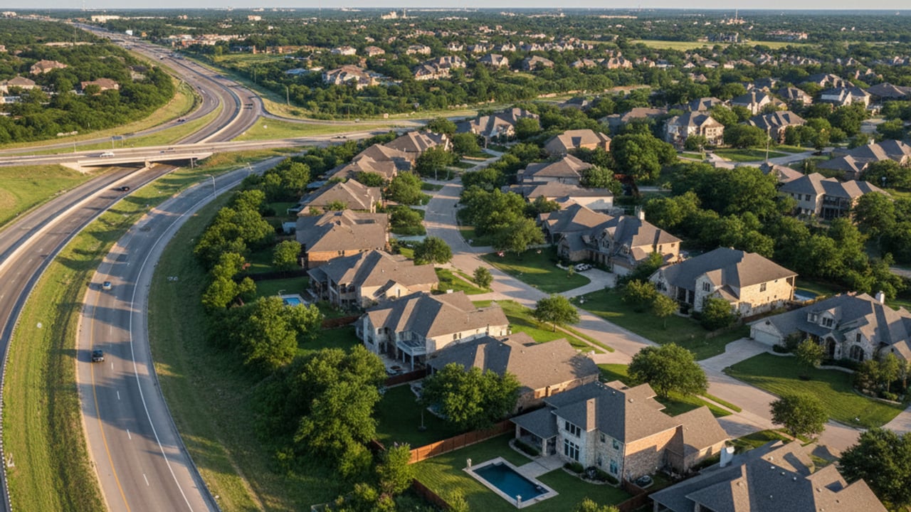
For many residents, the primary transportation concern is the daily drive into San Antonio. The commute via the Interstate 10 corridor generally takes 30 to 45 minutes to reach the downtown district under typical conditions. This roughly 30-mile journey serves as the main artery for professionals working at major medical centers or corporate campuses to the south.
Peak rush hour traffic will easily extend this timeline, especially where I-10 intersects with Loop 1604. Recent highway expansion projects have improved traffic flow, but morning slowdowns remain a reality you must factor into your schedule. Buyers should test this drive during their actual commute hours rather than relying on midday traffic estimates.
The convenience of this interstate access creates a distinct real estate advantage for neighborhoods located on the southern edge of the city. You sacrifice some rural seclusion, but gaining a 15-minute head start on the morning drive is often worth the trade-off. Properties closer to the highway consistently hold their value due to this commuter demand.
Local Infrastructure and Major Thoroughfares
Navigating within the city limits relies heavily on a few primary corridors that handle the bulk of daily traffic. Main Street, which operates as US 87, serves as the central spine of the city and hosts the highest concentration of local commerce. This route can become congested during weekend tourist peaks, meaning locals often utilize parallel side streets to bypass the central shopping district.
Highway 46 acts as the crucial east-west connector, linking the city to neighboring rural areas and other Texas Hill Country towns. This thoroughfare provides direct access to major grocery stores, local dining establishments, and expanding healthcare facilities. Purchasing a home off Highway 46 means you will rely on this two-lane road for nearly every daily errand, making traffic patterns here a crucial consideration.
The ongoing commercial development along these routes has shifted how residents plan their weekly shopping trips. Rather than driving into San Antonio for basic needs, locals can now access large-scale retail options right at the intersection of I-10 and Highway 46. This localized infrastructure significantly reduces the weekly mileage most residents put on their vehicles.
Public Transit and Airport Rideshare Availability
Traditional public bus systems do not operate extensive local routes within the city limits. Residents without a personal vehicle must rely on Alamo Regional Transit, which provides on-demand, curb-to-curb service throughout Kendall County. This service requires advance scheduling and operates primarily during standard business hours.
Securing a ride to San Antonio International Airport using a ridesharing company like Uber or Lyft is possible, but it requires planning. While drivers do operate locally, the inventory of available vehicles is much lower than in a major urban center. Booking your airport transport a day in advance is highly recommended to ensure you catch your flight without unwanted stress.
Walkability and Non-Motorized Transport Options
While a car is essential for regional travel, specific pockets of the city offer excellent pedestrian infrastructure. The historic downtown district, known locally as the Hill Country Mile, features continuous sidewalks connecting boutique shops, breweries, and restaurants. Buyers targeting this central zone can easily run weekend errands or grab dinner without ever turning a key.
The local trail network provides a scenic alternative to driving for recreation and short local trips. The Cibolo Trail serves as a primary pedestrian artery, linking the downtown area directly to local parks and the Cibolo Center for Conservation. This paved pathway parallels Cibolo Creek, offering miles of protected space away from vehicular traffic.
Prioritizing trail access is one of the smartest moves a buyer can make if they value outdoor recreation. Properties positioned within a short walk of these trailheads command higher price points, but they deliver an immediate lifestyle upgrade. The ability to bike from your front door to Main Street fundamentally changes how you interact with the city.
How Transit Routes and School Proximity Impact Real Estate
Transportation infrastructure directly dictates property values across the local housing market. Neighborhoods located within an approximate 5-to-10-minute drive of I-10 command a measurable premium for commuting convenience. Buyers are consistently willing to pay upwards of $500,000 for homes that minimize their time spent sitting in traffic.
Proximity to Boerne Independent School District campuses also heavily influences buyer demand in specific zip codes. Homes located along routes that offer straightforward access to these educational facilities sell faster than properties requiring complex morning navigation. The traffic flow around these campuses during drop-off hours is a major factor you must evaluate when touring homes.
You will notice a sharp pricing contrast between walkable historic properties and larger acreage homes located further out on Highway 46. A restored home near Main Street offers unparalleled convenience, while a rural property requires a longer drive for every gallon of milk or trip to Cascade Caverns. Your budget will stretch further on the outskirts, but you will pay for that difference at the gas pump.
Frequently Asked Questions About Getting Around Boerne
Does Boerne have Uber and other ridesharing services?
Yes, Uber and other ridesharing services do operate in the area. The number of active drivers is lower than in major cities, so wait times can occasionally exceed 20 minutes. Scheduling your rides in advance is the most reliable way to secure transportation, especially for early morning trips.
Is Boerne, Texas a walkable city?
The central historic district is highly walkable, featuring wide sidewalks and crosswalks along the Hill Country Mile. Outside of this downtown core, the city is primarily car-dependent for daily errands. The Cibolo Trail does provide excellent pedestrian connectivity between downtown and several major parks.
How can I get from San Antonio to Boerne without a car?
Traveling between these two cities without a personal vehicle requires using a rideshare service, a private taxi, or an airport shuttle. There is no direct public bus route connecting downtown San Antonio to Kendall County. Alamo Regional Transit can facilitate some regional trips, but it requires booking well ahead of your travel date.
